SPACE - Affordable Earth Observation
BY JAMES CARELESS
Affordable Earth Observation
Satellogic has the satellites and the advanced image processing technology to help enable and enhance Canada’s space-based capabilities.

With their ability to see what’s happening anywhere on the planet, Earth Observation (EO) satellites provide vital intelligence to a wide range of government agencies. Traditionally, they have fulfilled this role at a high financial cost to their users.
A case in point: The Canadian government currently relies on the RADARSAT Constellation Mission (RCM), a trio of EO satellites, to obtain daily scans of Canada and 90% of the Earth’s surface for intelligence reasons. But satellites age out, which is why the government is planning to replace the RCM operationally in 2033-2034.
Building and maintaining a whole new set of EO satellites is expensive. This is why obtaining this data from a third-party EO satellite provider — one who covers all the cost of running this system and simply charges for data access — is a cost-effective solution for EO data users.
This is precisely what Satellogic’s constellation of Low Earth Orbit (LEO) satellites can offer to the Canadian government: The EO data they need for a wide range of defence, environmental, and humanitarian reasons — at a cost Canada can easily afford.
THE SATELLOGIC MODEL 
Satellogic North America is a subsidiary of Earth Observation satellite company, Satellogic, with head office in Denver. Founded in 2010 by Argentinian engineering entrepreneurs Emiliano Kargieman and Gerardo Richarte, Satellogic has 30 small LEO satellites in orbit now. The company intends to expand its fleet to more than 200 LEOs enabling them to remap the surface of the Earth every single day.
In terms of coverage, the fleet flies North to South over the Earth in a near-Polar ‘sun-synchronous orbit’. This orbital path minimizes shadows caused by the Sun on the planet’s surface, while maximizing image clarity.
Satellogic North America can provide its clients with multiple daily visits of any point on Earth for still full-colour photo shoots. Its satellites can also shoot high-definition monochromatic videos during a pass, at a rate of 60 seconds at 10 frames per second.
“We think of Earth Observation data as a source of information that should be accessible on a global scale,” said Ryan McKinney, President of Satellogic North America. “Although we are privileged to serve defence government clients, our primary focus is on providing high-resolution, high-quality data for applications to all kinds of clients.”
“Our current fleet size gives us the ability to monitor sites multiple times a day, but we are not stopping there,” he added. “We have a frequent launch schedule and intend to deploy up to 21 satellites to our constellation in 2023. As a result, our ability to increase capacity and image resolution with rapid iterations gives our customers the opportunity to leverage the most up-to-date EO technology in orbit.”
KEEPING COSTS UNDER CONTROL
Ryan McKinney and Satellogic North America are working to provide a picture of the living Earth on a daily basis to aid in managing climate change and monitoring resource allocations. At the same time, they wanted the EO data gathered by their LEO fleet to be affordable and widely accessible. So, they designed the Satellogic satellite system to be as cost-effective as possible.
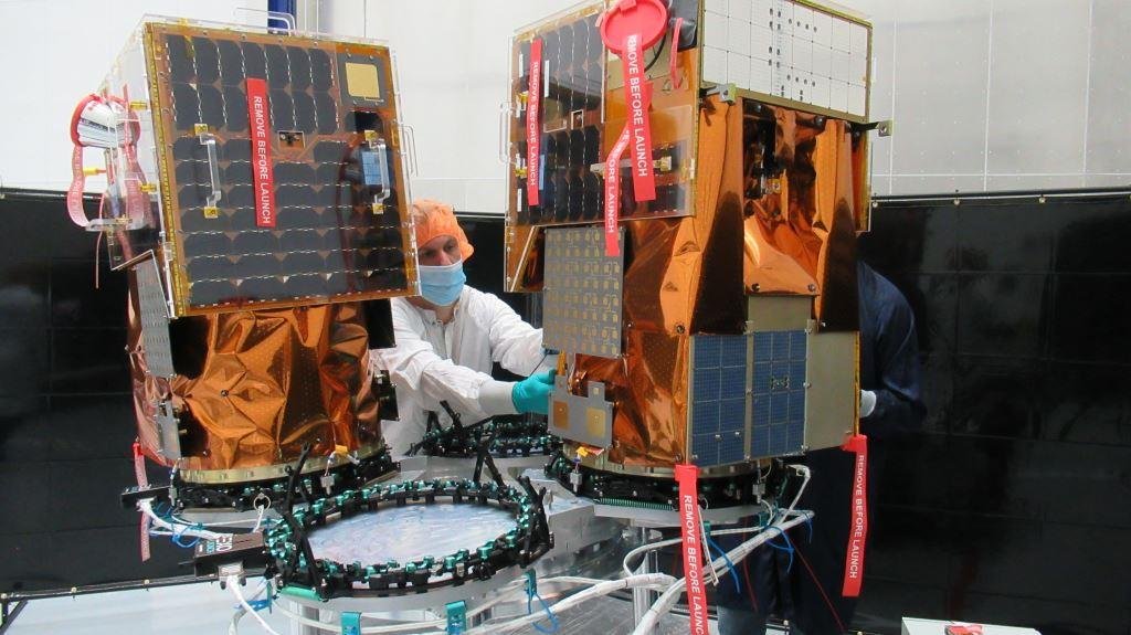
This is why the Satellogic fleet is composed of inexpensive, small, and modular NewSat LEO satellites, each measuring 51 × 57 × 82 cm in size and weighing just 38.5 kg/85 lb each. Designed by Satellogic co-founders Emiliano Kargieman and Gerardo Richarte, each NewSat spacecraft launches in groups of four on SpaceX’s Falcon 9 rockets. Yet, when coupled with Satellogic’s artificial intelligence-enhanced image processing technology, they can capture still images and videos in visible and infrared light at a ground resolution of 99 centimetres. In fact, the still images can even be processed to bring their resolution down to 70 centimetres. That’s more than enough detail to see what’s happening on the Earth’s surface below.
Satellogic offers this EO data to all of its clients based on a flexible licensing and rate schedule, with the clients specifying what content they need the company’s satellites to capture, wherever and whenever they need this work to be done. “At a very early stage of the business we realized that traditional data licensing structures were often too restrictive and not aligned with how customers wanted to interact with the data,” said McKinney. “So, we designed Satellogic’s licensing agreements to remove unnecessary barriers, increase collaboration, and optimize the value of derived insights — including permissions to develop derived products.”
The takeaway: “We’ve found a way to build very good satellites at a price point that allows us to make this EO data widely available to people who couldn’t afford it before,” McKinney said. “We want to keep our pricing down to make this possible. Yet, at the same time, we want to work with clients such as the Governments of Canada and the US, plus NATO as well. This is why we established Satellogic North America, where our big focus is aiming to provide this high quality EO data for these kinds of clients to use.”
THE MANY USES FOR EO DATA
According to Ryan McKinney, there are many ways in which government agencies can benefit from using Satellogic’s EO data, and many departments who will find this data to be useful.
In the military arena, “national defence and intelligence agencies have been monitoring geographically dispersed locations on a global scale for decades through activity indicators such as ‘change detection’,” he said. As the name suggests, change detection includes noticing ground-based differences over time in the positioning of objects like planes, ships, and personnel. Satellogic can fulfill all of these missions for them.
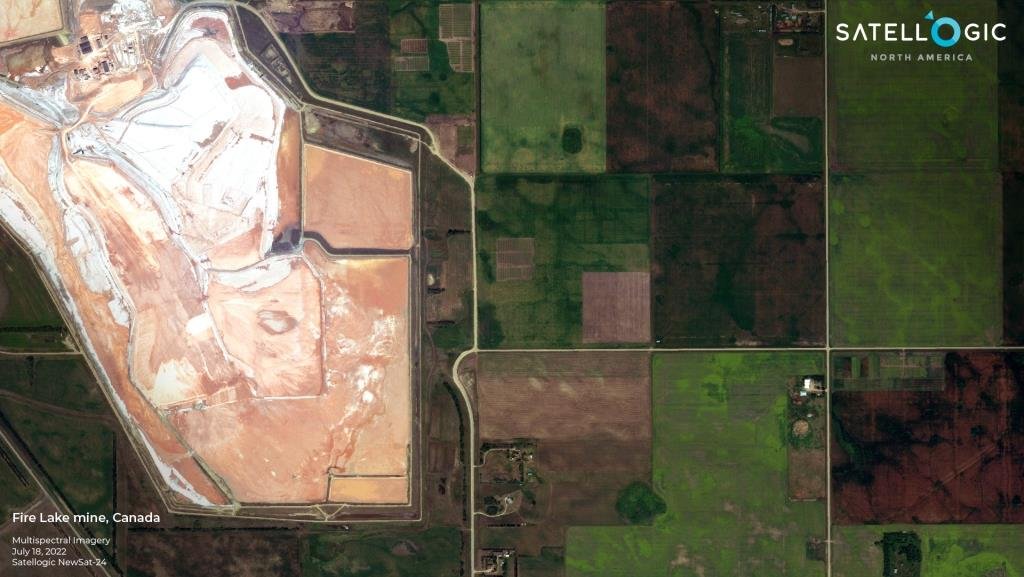
Other government departments can benefit by accessing the EO data being used by their military, with all of them being able to achieve better results due to improved situational awareness. “Our EO data is an excellent tool to help the government identify things like new construction, well pads, flaring, and open pit mine operations as well as deforestation plus other indicators and early warning signs of environmental risks,” explained McKinney. “There are also instances where interests align across all segments of the government, such as in the case of detecting change and assessing risk as it relates to climate change, global supply chain, and economic indicators.”
Here is a prime example of how civilian-focussed EO data can also be of use to military planners. “Canada recently announced its Critical Minerals Strategy as part of its efforts to become a global supplier for critical minerals and clean digital technologies,” McKinney told CDR. Approximately 60 different minerals and metals are produced in Canada at hundreds of mines, many of which are vital to the continued success of Canada’s economy and national security. Unfortunately, “these mines are geographically dispersed and often in remote areas where monitoring things like mine safety and climate impact can be expensive and manual labor intensive,” he said. “EO data provides insights on a national scale to help monitor these locations cost-effectively and efficiently, and to help government and business allocate necessary resources where they are needed most.”
GETTING MORE OUT OF EO DATA 
In the early days of EO data — specifically defence-related photography of military targets from orbit — the analysis of this precious intelligence was done manually by trained analysts.
In many instances, this method of human analysis remains the case, and it slows down the extraction of useful intelligence from this data. It can also overwhelm the agencies who use this approach due to the sheer volume of EO data available today.
For this reason, Satellogic supports the use of artificial intelligence/machine learning platforms (AI/ML) by its customers to ingest, sort, and sift out relevant information from EO data. AI/ML speeds up the analysis process without compromising on quality.
“Over the last five years, we've seen progress in using AI/ML platforms for analysing EO data and they're really starting to demonstrate value,” McKinney told CDR. “Early adopters of these types of collaborations benefit from the insights derived from these platforms. Meanwhile, insights that rely on planetary-scale, multimodal data capabilities have the potential to play influential roles in areas such as climate change, urban planning, supply chain, humanitarian aid and disaster relief, and homeland security, just to name a few.”
THE TOUGHEST OBSTACLE
Clearly, Satellogic has a solid business case to make to government EO users. But although this company and other Commercial Space players have been making inroads with government clients worldwide, there is still one big obstacle to them gaining the market share they deserve. Not surprisingly to those who work in the defence industry, this obstacle is simply the insulated and isolated ways in which governments and their militaries operate.
“EO data has been around for decades, with traditional use cases being heavily focused on supporting national defence/intelligence exercises and operations,” McKinney observed. “Unfortunately, many of those use cases required imagery providers to be siloed off into secure enclaves within the governments they support. This often means that data collected for a single operation couldn’t be shared with others within the government who could use the data for other purposes.”
Now there will always be instances when EO data can't and shouldn't be shared, but a vast majority of the data collected can safely and securely provide value beyond its initial intended uses, he explained. But changing ingrained government practices is never easy. This is why “EO providers such as Satellogic North America that want to enable cross collaboration within the government often struggle to get this point out in the open,” said McKinney.
A BRIGHT EO FUTURE 
Despite the challenges of convincing governments to use commercial satellite EO data, Ryan McKinney is optimistic about future prospects for Satellogic and similar companies.
“It is exciting to see how EO data is being combined with other data sets to unlock more comprehensive insights on a planetary scale, and I truly think we are only beginning to scratch the surface of what can really be done,” he said. “As capacity, resolution, and modalities continue to increase we will see new ways in which defence, intelligence, civil government, and commercial users can benefit from incorporating EO data into their workflows.”
“From a Satellogic perspective, I'm very excited about the potential of our satellites to help our customers and partners think past the raw data being collected,” continued McKinney. “In addition, we're positioning to add edge computing onto our satellites, which will enable us to provide onboard processing using AI/ML models that decrease latency while delivering data to meet very specific customer needs.”
A ROLE IN CANADA
For the Canadian government and the Department of National Defence (DND), the cost-effective, affordable and advanced alternative that Satellogic offers to building and maintaining successive generations of satellites is worthy of careful consideration.
This doesn’t mean that the successor to the RADARSAT Constellation Mission should be entirely sourced from the private sector: There are legitimate reasons of national security and sovereignty for Canada owning and operating defence-related EO satellites for its own behalf. 
At the same time, the expanded cross-department EO capabilities offered by Satellogic could safely fill many Canadian defence and intelligence requirements, and empower other government departments to do their jobs better and in a more timely manner. This is why this EO satellite platform warrants and deserves a serious look by DND and the Canadian government — not just for reasons of cost, but also because the Satellogic network is already in place and functioning.
This is certainly a role that Satellogic North America would be very comfortable filling for the Canadian government. “We want to be a data provider that delivers affordable, high-quality, high-resolution data, and we really want to be able to support any initiative that Canada has that can benefit from this kind of data,” McKinney told CDR. “We hope to be given opportunities to prove ourselves and really talk about how we can help enable and enhance the space-based capabilities of Canada. Satellogic certainly has the LEO satellites and the advanced image processing technology on hand today to do the job.”
James Careless is CDR’s Ottawa Bureau Chief

